"The pro-industry zealots now running the EPA's pesticide office are making a mockery of science and eliminating key safety measures, all for company profits."
Environmental and public health advocacy groups expressed alarm Friday after the Trump administration moved to increase the allowable level in U.S. waterways of a common herbicide linked to hermaphroditic amphibians and birth defects, cancer, and other harmful health effects in humans.
At issue in the proposal posted yesterday by the EPA is the threshold level of atrazine, the second most widely used herbicide in the U.S. Manufactured by Syngenta, atrazine is primarily used in agriculture as a weedkiller on crops. It is not authorized for use in the European Union, as the body said there wasn't enough data to prove it wouldn't have a harmful effect on groundwater.
"Human exposure to atrazine is linked to a number of serious health effects," according to a factsheet from Pesticide Action Network. "A potent endocrine disrupter, atrazine interferes with hormonal activity of animals and humans at extremely low doses."
The proposed change, said Nathan Donley, a senior scientist at the Center for Biological Diversity, "will likely lead to an increase in atrazine in drinking water, particularly in the Midwest."
As Donley's group and Environmental Working Group (EWG) explain in a press statement, the proposal regards what the EPA calls the Concentration Equivalent Level of Concern (CELOC).
"Atrazine levels above this threshold require mitigations to bring the water body back into compliance. Below, this level, no action is required," as Donley said in tweet.
Trump's EPA is proposing bumping up the level to a 60-day average concentration of 15 parts per billion (ppb) of atrazine, 50% higher than the current level of 10 ppb. In 2016 the agency proposed a level of just 3.4 ppb, but that Obama-era assessment, according to Trump's EPA, was "fundamentally flawed" and failed to take into consideration "the relevance of the individual studies."
Driving the push towards higher acceptable levels of atrazine, according to EWG and the Center, is the administration's goal of appeasing Big Ag and the pesticide industry.
"To please Syngenta, the Trump EPA has rejected decades of independent research showing atrazine can't be safely used at any level," said Donley. "The pro-industry zealots now running the EPA's pesticide office are making a mockery of science and eliminating key safety measures, all for company profits."
Olga Naidenko, EWG's vice president for science investigations, warned of the possible impacts to children.
"Atrazine sprayed on the fields ends up in our drinking water and affects the development of the fetus," said Naidenko. Thus, she said, the proposal should provoke "outrage" as it "will lead to more children being exposed to this toxic chemical."
“With Trump's EPA reversing even the most commonsense protections," added Donley, "our health, and the health of all species, is in serious danger.”
"Let's call this what it is: an excuse to abandon clean air, clean water, and chemical safety rules."
Advocates of strong public health protections responded with alarm to a Monday night New York Timesreport on the Environmental Protection Agency's new draft proposal for the Trump administration's drawn-out effort to dramatically scale back the scientific research that can be used in government policymaking.
"Let's call this what it is: an excuse to abandon clean air, clean water, and chemical safety rules," said Andrew Rosenberg, director of the Center for Science and Democracy at the Union of Concerned Scientists. "This is a blatant removal of well-established science from the policymaking process, to the benefit of polluters and at a huge cost to the marginalized communities who face the biggest threat from pollution."
The draft proposal (pdf), titled "Strengthening Transparency in Regulatory Science," would force the agency to only consider research that discloses all raw data, including private medical files. It follows a similar proposal unveiled by former EPA chief Scott Pruitt in April 2018 that provoked nearly 600,000 comments from the public, the majority of which were critical.
Pruitt's successor as EPA administrator, ex-lobbyist Andrew Wheeler, delayed the prior proposal, purportedly to consider concerns from environmental and public health groups. However, the new version "headed for White House review and obtained by The New York Times shows that the administration intends to widen its scope, not narrow it."
According to the Times:
The measure would make it more difficult to enact new clean air and water rules because many studies detailing the links between pollution and disease rely on personal health information gathered under confidentiality agreements. And, unlike a version of the proposal that surfaced in early 2018, this one could apply retroactively to public health regulations already in place.
"This means the EPA can justify rolling back rules or failing to update rules based on the best information to protect public health and the environment, which means more dirty air and more premature deaths," said Paul Billings, senior vice president for advocacy at the American Lung Association.
Public health experts warned that studies that have been used for decades—to show, for example, that mercury from power plants impairs brain development, or that lead in paint dust is tied to behavioral disorders in children—might be inadmissible when existing regulations come up for renewal.
One key example of scientific research that wouldn't be permissible for government use under the EPA proposal is a 1993 Harvard University project known as the Six Cities study, which connected air pollution to premature deaths and subsequently informed nationwide air quality policies.
"A separate internal EPA memo viewed by The New York Times shows that the agency had considered, but ultimately rejected, an option that might have allowed foundational studies like Harvard's Six Cities study to continue to be used," the newspaper reported Monday.
As journalist Emily Atkin put it in her HEATED newsletter Tuesday: "In other words, air pollution denial is becoming U.S. policy for the first time." She noted that this proposal "is a key priority of Steve Milloy, a former tobacco and fossil fuel industry lobbyist who served on Trump's EPA transition team."
Atkin recalled speaking with Stan Glantz, a professor of tobacco control at the University of California San Francisco, when reporting on Pruitt's version of the proposal last year. The tobacco industry, Glantz told her, "realized that, rather than fighting every single study that came out linking them to cancer, if they could get the rules of evidence changed, they wouldn't have to worry about it."
The Times report on Wheeler's revived and expanded version elicited impassioned warnings and critiques on Twitter:
An EPA spokesperson told the Times in an emailed statement that "the agency does not discuss draft, deliberative documents, or actions still under internal and interagency review." Wheeler, for his part, said in September that "we're moving forward [with the proposal] to ensure that the science supporting agency decisions is transparent and available for evaluation by the public and stakeholders."
UCS's Rosenberg said Wednesday that "Wheeler's claims about the need for these restrictions don't pass the laugh test. Everything about this rule makes a mockery of the EPA's claim that this change is necessary for transparency. This rule was driven by political operatives. It's being rushed through with minimal opportunity for public comment. And it introduces pointless hurdles and delays into the policymaking process that will compromise the federal government's ability to protect the public."
"The Trump administration has a clear pattern of sidelining science and undermining public health protections," he added. "If this rule is finalized, it would be one of the most damaging and far-reaching policy changes enacted by the administration. It would put the entire enterprise of developing science-based public health safeguards at risk."
The Times report came ahead of a Wednesday morning hearing planned by the Democrat-controlled U.S. House Science, Space, and Technology Committee about the Trump administration's effort to restrict the use of scientific research in federal policymaking, which will feature testimony from various scientists and public health experts.
When Apollo 11 landed on the Moon, it was a giant leap for mankind and a huge success for American engineering, but there was one aspect of the mission that hadn’t really gone as planned. When Neil Armstrong manually guided the lunar module to a safe touchdown, he had to override the computer which had the craft landing in a field of boulders. It left the demonstration of precision automated guidance to Apollo 12.
Fifty years ago this month, Apollo 12 successfully landed within a few hundred meters of its target, 400,000 kilometers (248,500 miles) away from where it lifted off. A key figure responsible for that precision landing was an unassuming Englishman living in the Arizona desert, Ewen Whitaker. Without the aid of computers or GPS, but with patience and an exhaustive knowledge of the geography of the Moon, Whitaker pinpointed where a robotic spacecraft had landed two years earlier.
As a scientist interested in the chronology of events on the Moon, I ultimately found myself analyzing rocks that had been brought back from the Moon by Apollo 12, working in a laboratory that Whitaker had helped establish. And even though Whitaker retired within months of my arrival in Tucson, it was a delight to get to know him and learn the stories of his quiet heroics.
The genesis of a lunar expert
Whitaker had long been fascinated by the Moon, and when pioneering planetary scientist Gerard Kuiper put out a request for collaborators at an international astronomical gathering in Dublin in 1956, Whitaker was the only one who responded. He went to join Kuiper at Yerkes Observatory in Wisconsin, then accompanied the group when it relocated to the University of Arizona and founded the Lunar and Planetary Laboratory.
As the group produced progressively better images and maps of the Moon, Whitaker absorbed the details with a devotion that meant that he almost certainly knew more lunar geography than any human ever had.
When NASA’s Surveyor 1 became the first robotic spacecraft to perform a soft landing on the Moon, in 1966, Whitaker wasn’t officially part of the team. But when the team studied the images from Surveyor 1’s camera, and published the location where they thought they had landed, Whitaker disagreed. When he examined the images of the peaks and craters and compared them to the highest-resolution images of the Moon’s surface available, he concluded the spacecraft was actually a few kilometers away from the published location. The team agreed.
After Apollo 11’s hair-raising final seconds before touchdown, precision landing became a high priority for Apollo 12. But the challenge was to establish the exact location of anything on a body that humans were just beginning to explore. A subsequent Surveyor mission provided the images Whitaker needed.
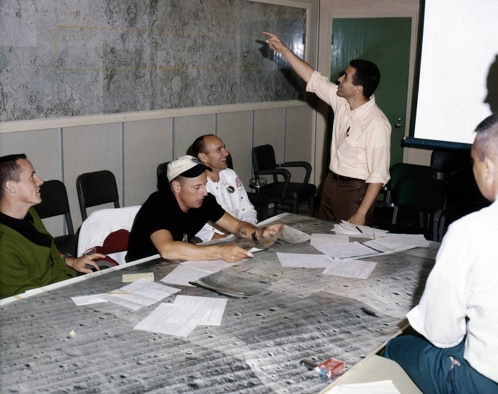
Left: Apollo 12 astronauts Pete Conrad (second from left, wearing white cap) and Alan Bean during final geology training. Astronauts Hoot Gibson (left) who served as capsule communicator during the Moon walks, and Harrison Schmitt (right), the only geologist astronaut.
NASA had landed the Surveyor 3 unmanned craft in 1967, and the location had several advantages for an Apollo 12 landing site. It was clearly an area where a spacecraft could safely land; it was near the equator, which made it easily accessible. And, if the landing was close enough to Surveyor 3, the astronauts could walk over and remove pieces of it to bring back to Earth. That way, scientists could study the wear and tear on the materials after spending two years on the lunar surface, exposed to vacuum, extreme temperatures, ionizing radiation and micrometeorite bombardment.
Given Whitaker’s success with locating Surveyor 1, he was asked to locate precisely Surveyor 3. It was a tougher task than finding Surveyor 1. Because Surveyor 3 had landed in a crater, the view was restricted, but Whitaker again poured over the best images he could find, and believed he had found the landing site.
Apollo 12 launched on November 14, 1969, and, other than being struck by lightning twice within the first minute after it lifted off, had an uneventful trip to the Moon. On November 19, the landing module, Intrepid, headed into a crater and safely touched down. When Mission Commander Pete Conrad stepped out onto the lunar surface, he saw Surveyor 3, about 200 meters away. Ewen Whitaker had gotten it right.
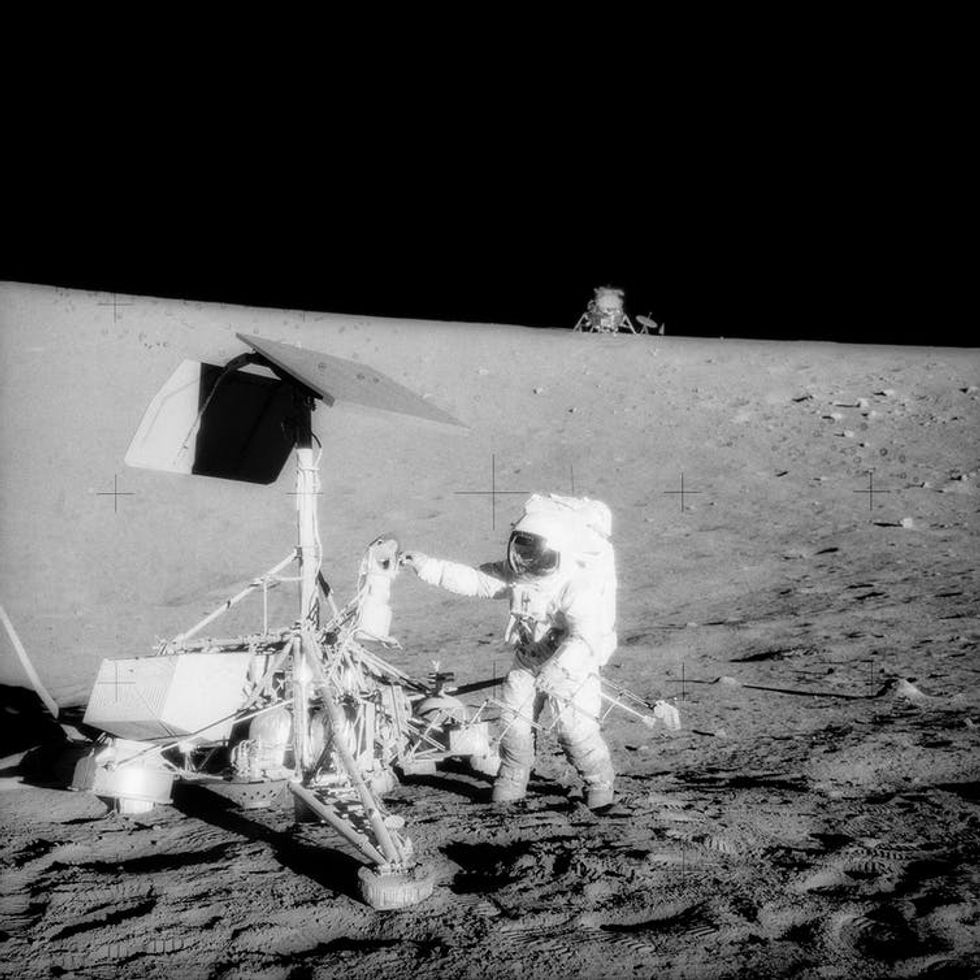
Conrad and fellow astronaut Alan Bean walked to the unmanned spacecraft, and some of the iconic images from the mission are of Conrad working on the Surveyor craft, including taking off its camera, which was returned to Earth for analysis.
Astronaut Pete Conrad examines the camera on Surveyor 3, with the Apollo 12 spacecraft in the background.
NASA
One of the ironies of that set of images is that the photographer, Bean, later became a very successful painter, with many of his paintings reflecting his lunar experiences, including the visit to Surveyor 3. Meanwhile, the astronauts sent a personal note to Whitaker, thanking him for his contributions, and that became one of Ewen’s prized possessions, framed and hanging on the wall of his house.
But the story of Whitaker and Bean wasn’t quite over. In the late 1990s, Bean was displaying artwork at a gallery in Tucson, and Whitaker went to see if he could meet him. Jim Scotti, an astronomer (in the Lunar and Planetary Lab) and space artist who knew both Whitaker and Bean, was at the meeting, and said that it seemed more like a reunion than a first meeting, with a happy mix of Whitaker’s English accent and Bean’s Texas twang.
And why not? For each of them, that day in November of 1969 had been the highlight of their professional careers, and neither could have done it without the other.
Icelandic seventh-grader Lilja Einarsdottir is on an unusual field trip with her class: they're measuring the Solheimajokull glacier to see how much it has shrunk in the past year, witnessing climate change first-hand.
"It is very beautiful but at the same time it is very sad to see how much it has melted," says Lilja, bundled up against the autumn chill in a blue pompom hat.
Each October since 2010, now-retired schoolteacher Jon Stefansson has brought students aged around 13 from a school in Hvolsvollur -- a village about 60 kilometers (40 miles) away -- to the glacier to record its evolution.
The results are chilling: nestled between two moss-covered mountain slopes, Solheimajokull has shrunk by an average of 40 meters (130 feet) per year in the past decade, according to the students' measurements.
On this blustery October day, the youngsters -- armed with a GPS, a measuring tape and two yellow flags -- calculate the distances on foot from various spots, struggling against strong winds.
Once done, some of the students hop in a dinghy and cross a lake of brown meltwater to reach an imposing wall of ice, the so-called terminus, or front of the glacier.
Here, they determine the gap between the terminus and a handpainted sign at the end of a footpath, where previous students have recorded their measurements over the years.
The numbers on the sign, pitched in black sand and steadied at the base by a pile of stones, indicate how many meters of ice have disappeared over the past years: "24", "50", "110".
"When (the first students) started here, you couldn't see any water. So it (the glacier) was very big at first," says Lilja.
- 400 glaciers under threat -
Glaciers cover about 11 percent of Iceland's surface, including Vatnajokull, the largest ice cap in Europe.
But they have lost about 250 cubic kilometers of ice in the past 25 years, or the equivalent of seven percent of their total volume.
"Now we have lakes that are forming in front of many of them," says glaciologist Hrafnhildur Hannesdottir of the Icelandic Meteorological Office.
Iceland in August unveiled a plaque commemorating the country's Okjokull glacier, the first to be stripped of its glacier status in 2014.
POOL/AFP/File / THIBAULT CAMUS Glaciers cover about 11 percent of Iceland's surface
The plaque was meant as a wake-up call on the effects of global warming as scientists fear the island's 400-plus glaciers could be gone by 2200.
Solheimajokull, where the students go, is a popular tourist spot as it is one of the closest to Reykjavik, only 150 kilometrers away. Icelandic Mountain Guides, one of three operators that runs year-round visits, had 27,000 clients in 2018.
Solheimajokull, about 10 kilometres long and two kilometers wide, is an outlet glacier of Myrdalsjokull, the country's fourth-biggest ice cap.
Under the ice here lies Katla, one of Iceland's most powerful volcanoes, which last erupted in 1901 and is long overdue to do so again, scientists say.
The glacier receded by 11 metres in 2019, a significant amount but far from the record 110 meters registered last year.
"It depends more or less on the weather (and) how the glacier is breaking," explains teacher Stefansson.
"Sometimes you get a big cliff falling into the water and then you get a very, very big measurement."
- Global warming 'proof' -
Since the school started its measurements, the glacier has shrunk by 380 meters in almost a decade.
"When we see this, it's like proof (of global warming). If we thought that we were maybe wrong, this is proof we weren't," says 12-year-old Birna Bjornsdottir.
POOL/AFP/File / THIBAULT CAMUS Solheimajokull has been receding every summer since 1996
The measurements are neither scientifically exact nor official but they do indicate the changes underway and their acceleration in recent years.
Official measurements from the Iceland Geological Society show Solheimajokull shrank by around 200 metres in 2018, putting it among the country's top three glacier shrinkages.
It has been receding every summer since 1996.
The melting can be observed with the naked eye, with drops of water dripping from the ice, sometimes running into little streams.
"I see a large change in the glacier's volume: it's a lot lower than it used to be," says Daniel Saulite, a Scottish guide who has worked on the glacier for five years.
"In the front, there is also a lot more crevassing, and also the access becomes increasingly difficult."
At the height of its empire, the inhabitants of ancient Rome genetically resembled the populations of the Eastern Mediterranean and Middle East, according to a DNA study published Thursday.
The paper is based on genome data of 127 individuals from 29 archaeological sites in and around the city state, spanning nearly 12,000 years of Roman prehistory and history.
Rome and central Italy's antiquity is well-documented in the rich archaeological and historical record, but relatively little genetic work had been carried out until now.
Writing in the journal Science, researchers from Stanford and Italian universities said people from the city's earliest eras and from after the Western empire's decline in the 4th Century CE genetically resembled other Western Europeans.
But during the imperial period, Romans had more in common with populations from Greece, Syria and Lebanon.
The earliest sequenced genomes, from three individuals living 9,000 to 12,000 years ago, resembled other European hunter-gatherers at the time.
Starting from 9,000 years ago, the genetic makeup of Romans again changed in line with the rest of Europe following an influx of farmers from Anatolia or modern Turkey.
Things started to change however from 900 BCE to 200 BCE, as Rome grew in size and importance, and the diversity shot up from 27 BCE to 300 CE, when the city was the capital to an empire of 50 million to 90 million people, stretching from North Africa to Britain to the Middle East.
Of the 48 individuals sampled from this period, only two showed strong genetic ties to Europe.
The genetic "diversity was just overwhelming," said Ron Pinhasi of the University of Vienna, who extracted DNA from the skeletons' ear bones.
After the empire split into two parts with the eastern capital in Constantinople (now Istanbul), Rome's diversity decreased once more.
Jonathan Pritchard, a population geneticist at Stanford University who sequenced and analyzed the DNA, said mass migration is sometimes thought to be a new phenomenon.
"But it's clear from ancient DNA that populations have been mixing at really high rates for a long time," he added.
The concept of a canary in a coal mine – a sensitive species that provides an alert to danger – originated with British miners, who carried actual canaries underground through the mid-1980s to detect the presence of deadly carbon monoxide gas. Today another bird, the Emperor Penguin, is providing a similar warning about the planetary effects of burning fossil fuels.
As a seabird ecologist, I develop mathematical models to understand and predict how seabirds respond to environmental change. My research integrates many areas of science, including the expertise of climatologists, to improve our ability to anticipate future ecological consequences of climate change.
Most recently, I worked with colleagues to combine what we know about the life history of Emperor Penguins with different potential climate scenarios outlined in the 2015 Paris Agreement, to combat climate change and adapt to its effects. We wanted to understand how climate change could affect this iconic species, whose unique life habits were documented in the award-winning film “March of the Penguins.”
Our newly published study found that if climate change continues at its current rate, Emperor Penguins could virtually disappear by the year 2100 due to loss of Antarctic sea ice. However, a more aggressive global climate policy can halt the penguins’ march to extinction.
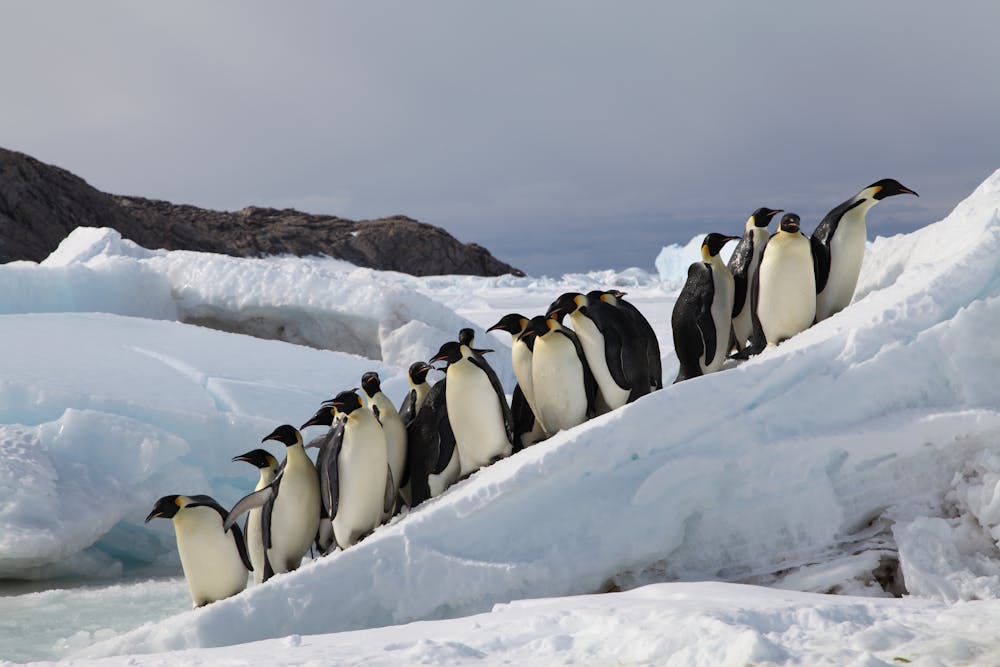
Emperor Penguins breeding on sea ice in Terre Adélie, Antarctica.
As many scientific reports have shown, human activities are increasing carbon dioxide concentrations in Earth’s atmosphere, which is warming the planet. Today atmospheric CO2 levels stand at slightly over 410 parts per million, well above anything the planet has experienced in millions of years.
If this trend continues, scientists project that CO2 in the atmosphere could reach 950 parts per million by 2100. These conditions would produce a very different world from today’s.
Emperor Penguins are living indicators whose population trends can illustrate the consequences of these changes. Although they are found in Antarctica, far from human civilization, they live in such delicate balance with their rapidly changing environment that they have become modern-day canaries.
A fate tied to sea ice
I have spent almost 20 years studying Emperor Penguins’ unique adaptations to the harsh conditions of their sea ice home. Each year, the surface of the ocean around Antarctica freezes over in the winter and melts back in summer. Penguins use the ice as a home base for breeding, feeding and molting, arriving at their colony from ocean waters in March or April after sea ice has formed for the Southern Hemisphere’s winter season.
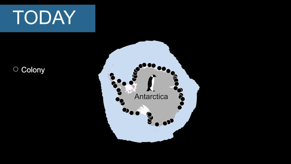
54 known Emperor Penguin colonies around Antarctica (black dots) and sea ice cover (blue color).
In mid-May the female lays a single egg. Throughout the winter, males keep the eggs warm while females make a long trek to open water to feed during the most unforgiving weather on Earth.
When female penguins return to their newly hatched chicks with food, the males have fasted for four months and lost almost half their weight. After the egg hatches, both parents take turns feeding and protecting their chick. In September, the adults leave their young so that they can both forage to meet their chick’s growing appetite. In December, everyone leaves the colony and returns to the ocean.
Emperor Penguin fathers incubate a single egg until it hatches.
Throughout this annual cycle, the penguins rely on a sea ice “Goldilocks zone” of conditions to thrive. They need openings in the ice that provide access to the water so they can feed, but also a thick, stable platform of ice to raise their chicks.
Penguin population trends
For more than 60 years, scientists have extensively studied one Emperor Penguin colony in Antarctica, called Terre Adélie. This research has enabled us to understand how sea ice conditions affect the birds’ population dynamics. In the 1970s, for example, the population experienced a dramatic decline when several consecutive years of low sea ice cover caused widespread deaths among male penguins.
Over the past 10 years, my colleagues and I have combined what we know about these relationships between sea ice and fluctuations in penguin life histories to create a demographic model that allows us to understand how sea ice conditions affect the abundance of Emperor Penguins, and to project their numbers based on forecasts of future sea ice cover in Antarctica.
Once we confirmed that our model successfully reproduced past observed trends in Emperor Penguin populations around all Antarctica, we expanded our analysis into a species-level threat assessment.
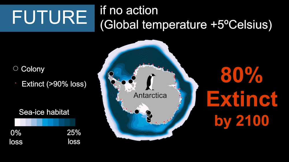
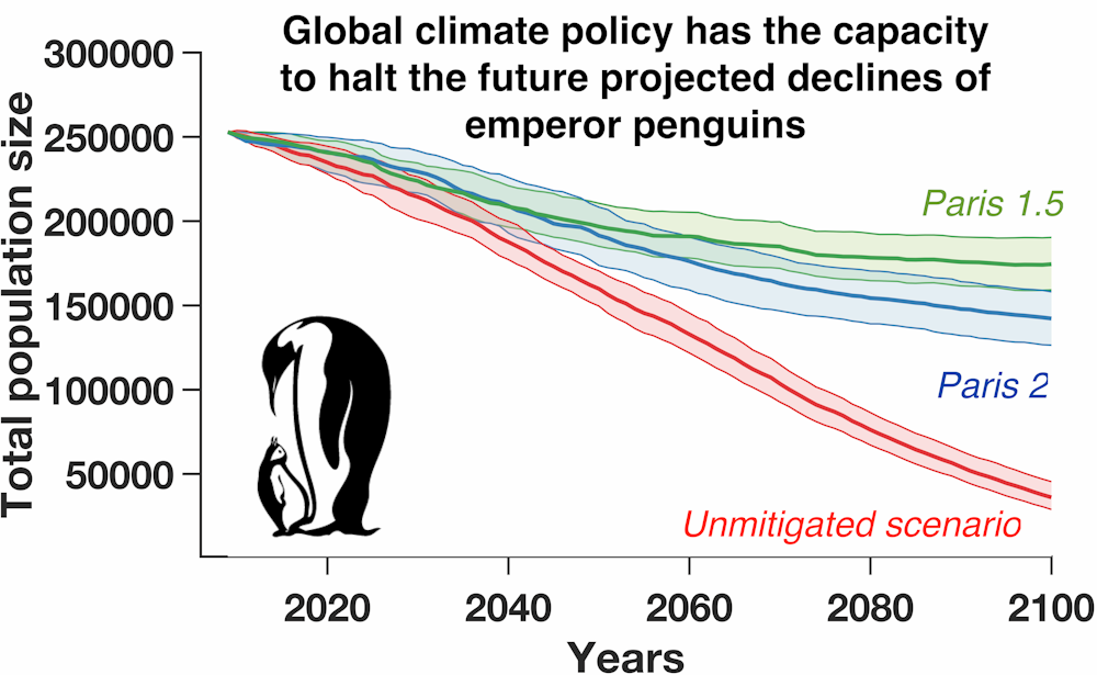
When we used a climate model linked to our population model to project what is likely to happen to sea ice if greenhouse gas emissions continue on their present trend, we found that all 54 known Emperor Penguin colonies would be in decline by 2100, and 80% of them would be quasi-extinct. Accordingly, we estimate that the total number of Emperor Penguins will decline by 86% relative to its current size of roughly 250,000 if nations fail to reduce their carbon dioxide emissions.
Without action to reduce global carbon dioxide emissions, sea ice loss (shown in blue) will eradicate most Emperor Penguin colonies by 2100.
However, if the global community acts to reduce greenhouse gas emissions and succeeds in stabilizing average global temperatures at 1.5 degrees Celsius (3 degrees Faherenheit) above pre-industrial levels, we estimate that Emperor Penguin numbers would decline by 31% – still drastic, but viable.
Less-stringent cuts in greenhouse gas emissions, leading to a global temperature rise of 2°C, would result in a 44% decline.
Our model indicates that these population declines will occur predominately in the first half of this century. Nonetheless, in a scenario in which the world meets the Paris climate targets, we project that the global Emperor Penguin population would nearly stabilize by 2100, and that viable refuges would remain available to support some colonies.
Global action to limit climate change through 2100 could greatly improve Emperor Penguins’ persistence/viability.
In a changing climate, individual penguins may move to new locations to find more suitable conditions. Our population model included complex dispersal processes to account for these movements. However, we find that these actions are not enough to offset climate-driven global population declines. In short, global climate policy has much more influence over the future of Emperor Penguins than the penguins’ ability to move to better habitat.
Our findings starkly illustrate the far-reaching implications of national climate policy decisions. Curbing carbon dioxide emissions has critical implications for Emperor Penguins and an untold number of other species for which science has yet to document such a plain-spoken warning.
A US pharmaceutical firm has identified a new subtype of the human immunodeficiency virus (HIV), and said the finding showed that cutting edge genome sequencing is helping researchers stay ahead of mutations.
The strain, HIV-1 Group M subtype L, has been recorded in three people from blood samples taken between the 1980s and 2001, all in the Democratic Republic of Congo, Abbott laboratories told AFP on Thursday.
To classify a new subtype, three cases must be discovered independently, according to guidelines issued in 2000.
Group M is the most prevalent form of the HIV-1 virus. Subtype L is now the 10th of this group and the first to be identified since the guidelines were issued.
Antiretroviral drugs, which today can reduce the viral load of an HIV carrier to the point at which the infection is both undetectable and cannot be transmitted further, have generally performed well against a variety of subtypes, according to research.
But there is also some evidence of subtype differences in drug resistance.
"Since subtype L is part of the major group of HIV, Group M, I would expect current treatments to work with it," Mary Rodgers, a principal scientist and head of the Global Viral Surveillance Program at Abbott told AFP.
She added that Abbott was making the sequence available to the research community to evaluate its impact on diagnostic testing, treatments and potential vaccines.
"In an increasingly connected world, we can no longer think of viruses being contained to one location," added Carole McArthur, a professor of oral and craniofacial sciences at the University of Missouri Kansas City, who co-authored a paper on the finding in the Journal of Acquired Immune Deficiency Syndromes (JAIDS).
"This discovery reminds us that to end the HIV pandemic, we must continue to outthink this continuously changing virus and use the latest advancements in technology and resources to monitor its evolution," she added.
The third sample was collected 18 years ago but was difficult to sequence given technical constraints at the time.
Abbott said the breakthrough was possible thanks to next-generation sequencing technology that allowed scientists to build up an entire genome at higher speed and lower cost.
"This scientific discovery can help us ensure we are stopping new pandemics in their tracks," Rogers said.
Every year West Texas experiences more and more small earthquakes. The study by the University of Texas at Austin documented more than 7,000 starting in 2009.
West Texas has seen a dramatic increase in earthquakes, jumping from 19 in 2009 to 1,600 in 2017 alone, according to a new study published Monday by the University of Texas at Austin.
The study, which was published in theJournal of Geophysical Research: Solid Earth, tracked nearly 20 years of seismic activity. The scientists documented more than 7,000 earthquakes near Pecos starting in 2009, most of them so small that no one felt them. The scientists used an earthquake monitoring system that was “some distance” from Pecos but sensitive enough to pick up vibrations 150 miles away.
“West Texas now has the highest seismicity rates in the state,” co-author and Souther Methodist University Associate Professor Heather DeShon said in a written statement. “What remained uncertain is when the earthquakes actually started. This study addresses that.”
While earthquake activity coincided with a large increase in oil and gas production in West Texas, the study does not try to link the two.
The research lays the groundwork to understand “the relationship between earthquakes and their human and natural causes,” Peter Hennings, the study's co-author and a research scientist at the UT Bureau of Economic Geology, said in a written statement.
West Texas has seen oil and gas production increaseat unprecedented rates, aggravating air pollution and leading to a housing crunch, according to a 2018 joint investigation by The Texas Tribune and Center for Public Integrity.
Disclosure: The University of Texas and Southern Methodist University have been financial supporters of The Texas Tribune, a nonprofit, nonpartisan news organization that is funded in part by donations from members, foundations and corporate sponsors. Financial supporters play no role in the Tribune's journalism. Find a complete list of them here.
Within just 50 light-years from Earth, there are about 1,560 stars, likely orbited by several thousand planets. About a thousand of these extrasolar planets – known as exoplanets – may be rocky and have a composition similar to Earth’s. Some may even harbor life. Over 99% of these alien worlds remain undiscovered — but this is about to change.
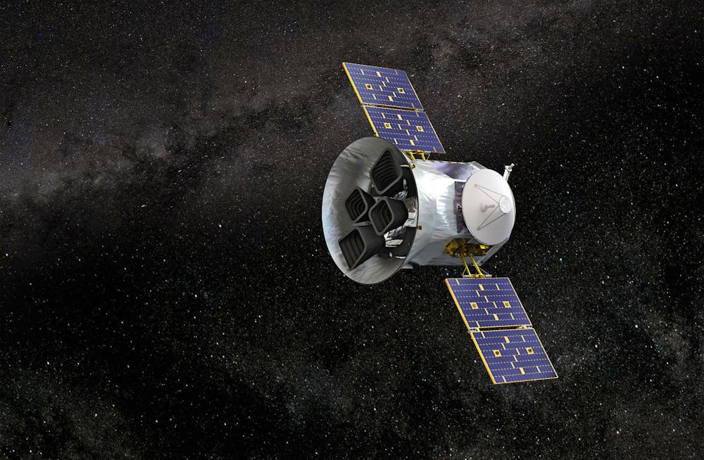
With NASA’s new exoplanet-hunter space telescope TESS, the all-sky search is on for possibly habitable planets close to our solar system. TESS — orbiting Earth every 13.7 days — and ground-based telescopes are poised to find hundreds of planets over the next few years. This could transform astronomers’ understanding of alien worlds around us and provide targets to scan with next-generation telescopes for signatures of life. In just over a year, TESS has identified more than 1,200 planetary candidates, 29 of which astronomers have already confirmed as planets. Given TESS’s unique ability to simultaneously search tens of thousands of stars for planets, the mission is expected to yield over 10,000 new worlds.
These are exciting times for astronomers and, especially, for those of us exploring exoplanets. Weare members of the planet-hunting Project EDEN, which also supports TESS’s work. We use telescopes on the ground and in space to find exoplanets to understand their properties and potential for harboring life.
Undiscovered worlds all around us
Worlds around us await discovery. Take, for example, Proxima Centauri, an unassuming, faint red star, invisible without a telescope. It is one of over a hundred billion or so such stars within our galaxy, unremarkable except for its status as our next-door neighbor. Orbiting Proxima is a fascinating but mysterious world, called Proxmia b, discovered only in 2016.
And that is what makes this planet so exciting: It lies in the “habitable” zone and just might have properties similar to Earth’s, like a surface, liquid water, and — who knows? — maybe even an atmosphere bearing the telltale chemical signs of life.
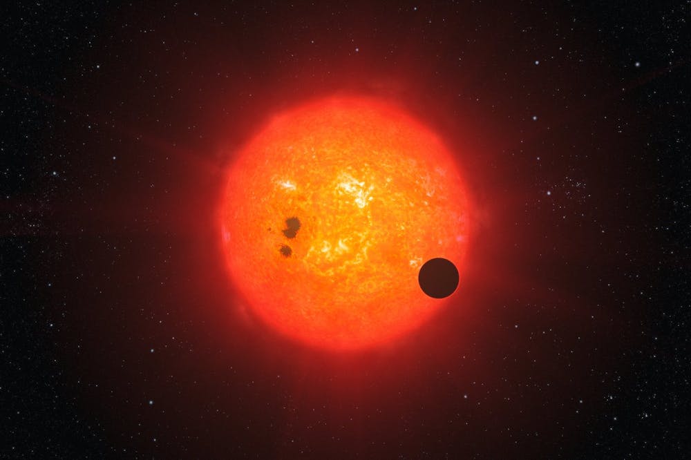
NASA’s TESS mission launched in April 2018 to hunt for other broadly Earth-sized planets, but with a different method. TESS is looking for rare dimming events that happen when planets pass in front of their host stars, blocking some starlight. These transit events indicate not only the presence of the planets, but also their sizes and orbits.
Finding a new transiting exoplanet is a big deal for astronomers like us because, unlike those found through stellar wobbles, worlds seen transiting can be studied further to determine their densities and atmospheric compositions.
By measuring the depth of the dip in brightness and knowing the size of the star, scientists can determine the size or radius of the planet.
For us, the most exciting exoplanets are the smallest ones, which TESS can detect when they orbit small stars called red dwarfs – stars with masses less than half the mass of our Sun.
Each of these systems is unique. For example, LP 791-18 is a red dwarf star 86 light-years from Earth around which TESS found two worlds. The first is a “super-Earth,” a planet larger than Earth but probably still mostly rocky, and the second is a “mini-Neptune,” a planet smaller than Neptune but gas- and ice-rich. Neither of these planets have counterparts in our solar system.
Among astronomers’ current favorites of the new broadly Earth-sized planets is LHS 3884b, a scorching “hot Earth” that orbits its sun so quickly that on it you could celebrate your birthday every 11 hours.
Artist’s impression of an exoplanet transiting a red dwarf star.
ESO/L. Calçada
No Earth-like worlds yet
But how Earth-like are Earth-sized planets? The promise of finding nearby worlds for detailed studies is already paying off. A team of astronomers observed the hot super-Earth LHS 3884b with the Hubble Space Telescope and found the planet to be a horrible vacation spot, without even an atmosphere. It is just a bare rock with temperatures ranging from over 700 C (1300 Fahrenheit) at noon to near absolute zero (-460 Fahrenheit) at midnight.
The TESS mission was initially funded for two years. But the spacecraft is in excellent shape and NASA recently extended the mission through 2022, doubling the time TESS will have to scan nearby, bright stars for transits.
However, finding exoplanets around the coolest stars — those with temperatures less than about 2700 C (4900 F) — will still be a challenge due to their extreme faintness. Since ultracool dwarfs provide our best opportunity to find and study exoplanets with sizes and temperatures similar to Earth’s, other focused planet searches are picking up where TESS leaves off.
Illustration of TESS, NASA’s Transiting Exoplanet Survey Satellite.
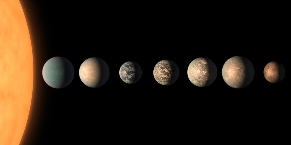
It also demonstrated how small telescopes — relative to the powerful behemoths of our age — can still make transformational discoveries. With patience and persistence, the TRAPPIST telescope scanned nearby faint, red dwarf stars from its high-mountain perch in the Atacama desert for small, telltale dips in their brightnesses. Eventually, it spotted transits in the data for the red dwarf TRAPPIST-1, which — although just 41 light-years away — is too faint for TESS’s four 10-cm (4-inch) diameter lenses. Its Earth-sized worlds would have remained undiscovered had the TRAPPIST team’s larger telescope not found them.
Two projects have upped up the game in the search for exo-Earth candidates around nearby red dwarfs. The SPECULOOS team installed four robotic telescopes – also in the Atacama desert – and one in the Northern Hemisphere. Our Exoearth Discovery and Exploration Network – Project EDEN – uses nine telescopes in Arizona, Italy, Spain and Taiwan to observe red dwarf stars continuously.
The SPECULOOS and EDEN telescopes are much larger than TESS’s small lenses and can find planets around stars too faint for TESS to study, including some of the transiting Earth-sized planets closest to us.
This artist’s concept shows what the TRAPPIST-1 planetary system may look like, based on available data about the planets’ diameters, masses and distances from the host star, as of February 2018.
The next decade is likely to be remembered as the time when we opened our eyes to the incredible diversity of other worlds. TESS is likely to find between 10,000 and 15,000 exoplanet candidates by 2025. By 2030, the European Space Agency’s GAIA and PLATO missions are expected to find another 20,000-35,000 planets. GAIA will look for stellar wobbles introduced by planets, while PLATO will search for planetary transits as TESS does.
However, even among the thousands of planets that will soon be found, the exoplanets closest to our solar system will remain special. Many of these worlds can be studied in great detail – including the search for signs of life. Discoveries of the nearest worlds also represent major steps in humanity’s progress in exploring the universe we live in. After mapping our own planet and then the solar system, we now turn to nearby planetary systems. Perhaps one day Proxima b or another nearby world astronomers have yet to find will be the target for interstellar probes, like Project Starshot, or even crewed starships. But first we’ve got to put these worlds on the map.
Timeline of discoveries of exoplanetary systems within 50 lightyears of the Sun. Credit: Project EDEN/ Daniel Apai and Benjamin Rackham.
Scientists have used a modified bike helmet to create a device that can monitor brain activity in children in realtime.
The technology may eventually be used on patients with neurodevelopmental disorders such as autism and epilepsy, they reported Tuesday in Nature Communications.
Researchers inserted a wearable magnetoencephalography (MEG) device into a standard bike helmet, and successfully recorded the brain's response to maternal touch in children aged two to five.
With standard equipment, it is very difficult to scan children under the age of eight, said Matthew Brookes, who worked on the device and authored the report.
"This is because in younger children, their heads are too small to fit the scanner properly and that means loss of data quality," he told AFP.
"In addition younger subjects tend to move more."
The device is equipped with small, lightweight sensors that prevent the scan from being affected by head movement.
Children can wear replicas of the helmet while at home to reduce anxiety during the scanning, the researchers said.
The technology isn't limited to children.
Brookes and his colleagues used larger versions of the device to record brain activity on a teenager playing video games, and a 24-year-old playing the ukelele.
Brookes said his colleagues at University College London were working on the clinical use of the MEG device -- including diagnosis and surgical mapping -- for adults and children with epilepsy.
He is hopeful that applications can be expanded to other conditions, such as brain injury, mental health and dementia.
"Obviously at the moment it remains nascent technology and is in the hands of clinical researchers. However, we hope that it will be used to scan patients within two to three years," Brookes said.
Brazilian President Jair Bolsonaro said Sunday that "the worst is yet to come" with an oil spill that has affected more than 200 beaches on the country's coast.
"What came so far and what was collected is a small amount of what was spilled," Bolsonaro said in an interview with Record television.
He said he did not know if additional oil would impact his country's coastline, but that "everything indicates that the currents went to the coast of Brazil."
Oil slicks have been appearing for three months off the coast of northeast Brazil and fouling beaches along a 2,000 kilometer (1,250 mile) area of Brazil's most celebrated shoreline.
Crews and volunteers have cleaned up tons of oil on the beaches.
Officials say it not yet possible to quantify the environmental and economic damage from the oil slicks.
The government on Friday named a Greek-flagged tanker as the prime suspect behind the oil slicks.
The ship Bouboulina took on oil in Venezuela and was headed for Singapore, it said.
The space agency Inpe said Friday there might still be oil at sea being pushed by currents and it could reach the states of Espiritu Santo and Rio de Janeiro in southeast Brazil.
Another autumn, more fires, more refugees and incinerated homes. For California, flames have become the colors of fall.
Free-burning fire is the proximate provocation for the havoc, since its ember storms are engulfing landscapes. But in the hands of humans, combustion is also the deeper cause. Modern societies are burning lithic landscapes - once-living biomass now fossilized into coal, gas and oil - which is aggravating the burning of living landscapes.
The influence doesn’t come only through climate change, although that is clearly a factor. The transition to a fossil fuel civilization also affects how people in industrial societies live on the land and what kind of fire practices they adopt.
Even without climate change, a serious fire problem would exist. U.S. land agencies reformed policies to reinstate good fire 40 to 50 years ago, but outside a few locales, it has not been achievable at scale.
What were lithic landscapes have been exhumed and no longer only underlie living ones. In effect, once released, the lithic overlies the living and the two different kinds of burning interact in ways that sometimes compete and sometimes collude. Like the power lines that have sparked so many wildfires, the two fires are crossing, with lethal consequences.
California’s Santa Ana and Diablo winds can drive explosive wildfire growth.
Fire as framework
As a historian of fire, I know that no single factor drives it. Flames synthesize their surroundings. Fire is a driverless car that barrels down the road integrating whatever is around it.
Sometimes it confronts a sharp curve called climate change. Sometimes it’s a tricky intersection where townscape and countryside meet. Sometimes it’s road hazards left from past accidents, like logging slash, invasive grasses or postburn environments.
Climate change acts as a performance enhancer, and understandably, it claims most of the attention because it’s global and its reach extends beyond flames to oceans, mass extinctions and other knock-on effects. But climate change is not enough by itself to account for the plague of megafires. Climate integrates many factors, and so does fire. Their interplay makes attribution tricky.
Instead, consider fire in all its manifestations as the informing narrative. The critical inflection in modern times occurred when humans began to burn fossilized rather than living biomass. That set into motion a “pyric transition” that resembles the demographic transition which accompanies industrialization as human populations first expand, then recede. Something similar happens with the population of fires, as new ignition sources and fuels become available while old ones persist.
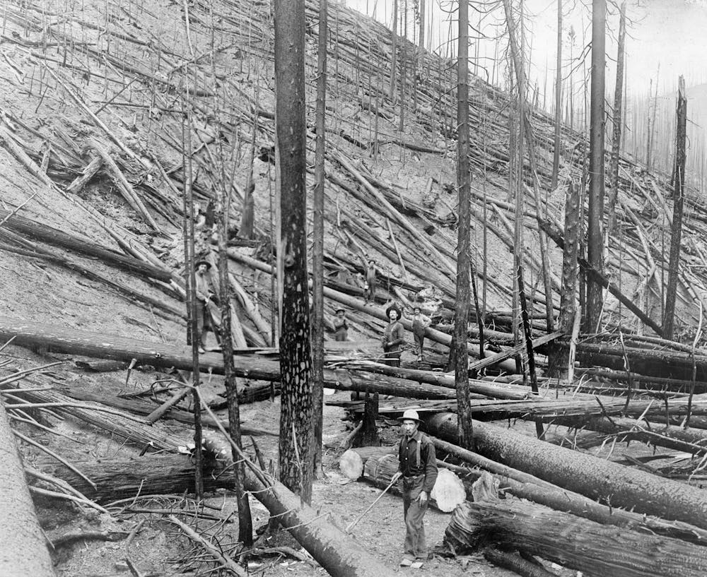
In the U.S., the transition sparked a wave of monster fires that rode the rails of settlement – fires an order of magnitude larger and more lethal than those of recent decades. Land clearing and logging slash fed serial conflagrations, which blew up in the late 19th and early 20th centuries, the waning decades of the Little Ice Age.
The Great Fire of 1910, which killed 78 firefighters in Idaho (shown) and Montana, led to a half-century of forest management focused on fire suppression.
It was a period of flame-catalyzed havoc that inspired state-sponsored conservation and a determination to eliminate free-burning flame. Led by foresters, the belief spread that fire on landscapes could be caged, as it was in furnaces and dynamos.
Eventually, as technological substitution (think of replacing candles with lightbulbs) and active suppression reduced the presence of open flame, the population of fires fell to the point where fire could no longer do the ecological work required. Meanwhile, society reorganized itself around fossil fuels, adapting to the combustion of lithic landscapes and ignoring the fire latent in living ones.
Now the sources overload the sinks: Too much fossil biomass is burned to be absorbed within ancient ecological bounds. Fuels in the living landscape pile up and rearrange themselves. The climate is unhinged. When flame returns, as it must, it comes as wildfire.
Welcome to the Pyrocene
Widen the aperture a bit, and we can envision Earth entering a fire age comparable to the ice ages of the Pleistocene, complete with the pyric equivalent of ice sheets, pluvial lakes, periglacial outwash plains, mass extinctions, and sea level changes. It’s an epoch in which fire is both prime mover and principal expression.
Even climate history has become a subset of fire history. Humanity’s firepower underwrites the Anthropocene, which is the outcome not just of human meddling but of a particular kind of meddling through humanity’s species monopoly over fire.
The interaction of these two realms of fire has not been much studied. It’s been a stretch to fully include human fire practices within traditional ecology. But industrial fire, unlike landscape fires, is solely a product of human finagling, and so has stood outside the bounds of ecological science. It’s as though the intellectual sink for understanding can no more hold the new realm of burning than nature can its emissions.
Yet in humanity – the keystone species for fire on Earth – those two arenas of earthly burning, like smoke from separate fires drawn into a single convective column, are merging. Their give and take is reshaping the planet.
In the developed world, industrial combustion arranges agriculture, built environments, peri-urban settings and reserves for wildlands – all the stuff available for landscape fire. Societies even fight landscape fire with the counterforce of industrial fire in the form of pumps, engines, aircraft and vehicles to haul crews. The interaction of the two realms of fire determines not only what gets burned, but also what needs to be burned and isn’t. It changes the road fire drives down.
Add up all the effects, direct and indirect – the areas burning, the areas needing to be burned, the off-site impacts with damaged watersheds and airsheds, the unraveling of biotas, the pervasive power of climate change, rising sea levels, a mass extinction, the disruption of human life and habitats – and you have a pyrogeography that looks eerily like an ice age for fire. You have a Pyrocene. The contours of such an epoch are already becoming visible through the smoke.
Destructive wildfires have ripped through California, threatening homes and famous landmarks, and forcing power outages that have plunged millions into darkness.
Everything from climate change to corporate negligence has been blamed for the chaos, which has seen hundreds of thousands evacuated, and hundreds of structures destroyed.
But how do these fires compare to previous years?
- Not remarkable -- yet -
Though terrible in terms of sheer size and destruction, this year's wildfires in California are not setting any records.
The 20 worst California wildfires on record all destroyed over 500 structures, or burned 140,000 acres, according to state agency Cal Fire. This year's biggest -- the Kincade Fire -- has destroyed 206 structures over 76,825 acres so far.
Remarkably, there have been no fatalities. Last year, a single fire that destroyed the town of Paradise killed 86 people.
But the threat has not passed. Dangerous winds were set to fan flames through Thursday, and some of California's worst blazes have struck as late as December.
"We are still at this point not out of the woods in terms of fire season, and we won't be until there is significant rainfall in both northern and southern California," said Crystal Kolden, a University of Idaho scientist who specializes in wildfires.
- Unique dangers -
This year's wildfires have been exceptional in several ways, however, with rare "extreme" wind warnings issued around Los Angeles.
Firefighters face a highly unusual challenge -- fires sweeping north and south California simultaneously. The state typically moves firefighters around to focus resources where needed. This year, forces have been split in half.
October wildfires in arid southern California are common. But due to climate change, even northern regions have still not had rainfall, said Kolden.
"The wind is nothing new. But it will be incredibly dry when those winds come," she said.
Ironically, heavy rain back in the spring made the situation worse, said Thomas Wieczorek, head of the Center for Public Safety Management.
"It's good and bad news. While it did end the drought in some parts of the state, it accelerated new growth that has now dried out."
On top of that, Californians have faced power outages. These have likely prevented some fires, but have left residents without electricity or internet, and in the dark about the next inferno threat.
"There's this sense of being fairly helpless. And this is unprecedented in that way," added Kolden.
- Planning, caution, luck -
If the wildfires have so far been less destructive than 2017 and 2018, it begs the question -- why?
Multiple factors likely all contribute.
While winds are roaring, temperatures in California this week are not especially high.
And a lot of proactive work has been done to reduce ignition risk.
"Cal Fire hired additional firefighters in preparation for this year, and so far it's been lucky that fires have been caught somewhat early on, before they've had a chance to explode," said Wieczorek.
With memories of last year's fatalities fresh, members of the public could simply just be acting more cautiously.
And another aspect is hard to measure.
"One factor is of course just pure luck, in terms of where the ignition starts and how things go," said Kolden.
- Future danger -
Even if 2019 ends up less destructive, omens for the future are not good. Several factors besides climate change put California at greater risk with each passing year.
Success preventing fires in recent decades has meant massive buildup of flammable vegetation. One major fear is that the Kincade Fire could leap over Highway 101 into a tinder-box region that hasn't burned since the 1940s.
California's housing boom also raises the risk. As the population soars, newly built homes made of wood provide additional fuel for flames.
And while power companies absorb much of the blame for recent fires, other human activity is far more culpable.
A recent study found equipment use -- for instance, weed-trimmers striking rocks -- was the main human cause of fire in California, followed by cigarette butts, campfires and arson.
The more people live in California, the more often these will occur.





 POOL/AFP/File / THIBAULT CAMUS
  POOL/AFP/File / THIBAULT CAMUS